
MHT Day 19: Over the Bitterroots to Nez Perce Country
On September 11, 1805, the Corps of Discovery left their camp at Travelers Rest and started their trek up and over the Bitterroot Mountains. Eleven days later they emerged from the mountains onto a prairie where they received food and a friendly greeting by a band of Nez Perce. That eleven day period was the most dangerous and most difficult stretch the Corps had experienced since leaving St. Louis.
The first several days of the journey the route was steep and game was scarce but they continued on, even finding a hot springs on September 13 used by Indians for bathing. Private Joseph Whitehouse, who also kept a journal during the Expedition, wrote that they
passed a warm Spring, which nearly boiled where it Issued out of the rocks a Short distance below the natives has dammed it up to bathe themselves in, and the water in that place is considerable above blood heat. it runs out in Sundry places and Some places cooler than others. Several of us drank of the water, it has a little sulpur taste and verry clear. these Springs are very beautiful to See, and we think them to be as good to bathe in &c. as any other ever yet found in the United States.
An omen of what was to come, however, occurred after they left the springs and their Shoshone guide, who they called Toby, took them down the wrong path resulting in a laborious trek up the side of a steep mountain to regain the correct path. The next day, because the hunters had been largely unsuccessful in their pursuits, the party killed and ate one of the horses they had purchased from the Indians. They named the place where they camped that night “Colt Killed Creek.” On their fifth day crossing the Bitterroots, September 15, after a particularly arduous climb during which several horses fell down the mountainside, Clark offered this description:
From this mountain I could observe high ruged mountains in every direction as far as I could See. with the greatest exertion we Could only make 12 miles up the mountain and encamped on the top of the mountain near a Bank of old Snow about 3 feet deep lying on the Northern Side of the mountain and in Small banks on the top & leavel parts of the mountain, we melted the Snow to drink, and Cook our horse flesh to eat.
On the next day, with more than half of their mountainous trek still ahead of them, snow fell on the party making conditions even more precarious as they trudged through some of the most rugged mountains in the continental United States. Private Whitehouse wrote this description of that depressing day:
We were all surprized when we awoke this morning; to find ourselves covered with Snow, which was 2 Inches deep . . . some of our party are without Socks, and are forced to wrap Rags round their feet to keep out the cold. The Snow fell so fast that it is now from 5 to 6 inches deep & where old the Snow remained it was considerably deeper . . . . The party were all much fataigued & hungry, our officers had a Colt killed and the party eat the half of it this evening.
By the seventh day, having killed and eaten three horses, Clark took six hunters and went ahead of the party, hoping to kill game and leave meat near the trail for the remainder to find and eat. Clark described the plan this way:
The want of provisions together with the dificuely of passing those emence mountains dampened the Spirits of the party which induced us to resort to Some plan of reviving ther Sperits. I deturmined to take a party of the hunters and proceed on in advance to Some leavel Country, where there was game kill Some meat & Send it back, &c
On September 19, from a high peak over which they were crossing, Lewis saw a level plain in the distance, about 60 miles away, but they, quite literally, were not out of the woods yet. Sergeant Patrick Gass wrote in his journal about both privation and hope:
The men are becoming lean and debilitated, on account of the scarcity and poor quality of the provisions on which we subsist: our horses’ feet are also becoming very sore. We have, however, some hopes of getting soon out of this horrible mountainous desert, as we have discovered the appearance of a valley or level part of the country about 40 miles ahead. When this discovery was made there was as much joy and rejoicing among the corps, as happens among passengers at sea, who have experienced a dangerous and protracted voyage, when they first discover land on the long looked for coast.
Clark and his advance party made contact on September 20 with a small village of Nez Perce on the plains Lewis had seen, but the latter would not emerge from the mountains until September 22, when he wrote, “the pleasure I now felt in having tryumphed over the rocky Mountains and decending once more to a level and fertile country where there was every rational hope of finding a comfortable subsistence for myself and party can be more readily conceived than expressed.”
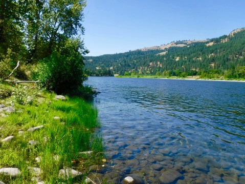
The Nez Perce, who numbered in the hundreds in this area and could easily have killed the weakened troops, provided camas roots and salmon for the famished men who wolfed down huge portions of the unfamiliar food only to be stricken for the next several days with severe cramps and diarrhea, prolonging their recovery and, in several cases, nearly killing a couple of them. But they finally recovered enough to begin building five canoes that would take them down the Clearwater River to the Snake River and on to the Columbia River. On October 7 they launched all their new canoes, built with the help of the Nez Perce who had also agreed to look after the expedition’s 38 remaining horses until they returned. Four days after launching their new craft, they reached the confluence of the Clearwater and Snake Rivers, where I am spending the night.
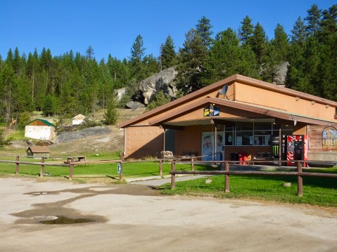
Well that was their trip from Lolo/Travelers Rest to the Snake River at Clarkston, Washington. Mine was a damn site better. The day started off cool, but not as cool as I had thought it might be up in the mountains. After a hardy breakfast in Missoula, I packed my gear on the bike, donned my leather jacket and gloves and headed to my first stop–Lolo Hot Springs. I knew it had been commercialized but not to what extent. There no longer exists a free-flowing hot spring, only a worn-out, swimming pool and soaking pool at a cheesy resort. I did find some warm water to stick my hand it, but it must have been some distance from the source since no skin peeled off. So, I proceeded on.
I’m sure it was a beautiful spot when Lewis and Clark were there.
At Lolo Pass, I stood at or near the spot where the Corps crossed the Continental Divide before being led astray again by their Shoshone guide and having to backtrack and climb one of the steepest inclines they encountered just to get back on the trail. I also had a chance to visit Packer’s Meadow, where they rested, grazed their horses, and got fresh water.
But the best part of the ride between Lolo and the Clearwater River on the other side of the mountains was. . . .well, it was the ride. U.S. 12 is one of the great motorcycle rides in the west. More than 100 miles of mostly gentle curves along a beautiful, flowing Lolo Creek on the Montana side and the Lochsa River on the Idaho Side. Interestingly, the waters of both rivers eventually ends up in the Columbia River. This road is a motorcyclist’s dream. Lots of pull offs to use if you want to see the river at a much slower pace or if slow-paced cars with courteous drivers want to use them to let impatient bikers pass.
I mostly behaved myself with the throttle, but I found I disagreed from time to time with Law Enforcement’s suggested speeds and I exceeded their recommendations, especially on the Idaho side where they laid about 50 miles of new surface just last year. If they went to all that trouble to make the roads more conducive to speed, it was the least I could do to oblige them.
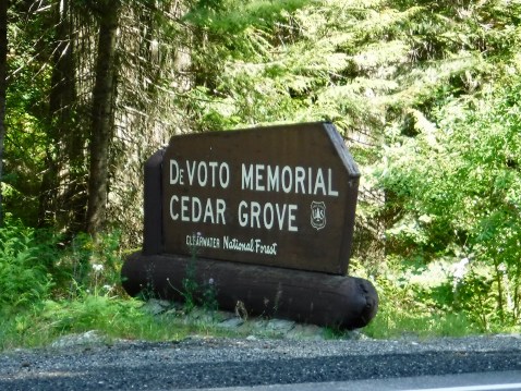
I did make one other stop that had been recommended to me by one of the historians I met at the beginning of this trip. A grove of old-growth cedar trees was named for Bernard DeVoto, one of the great historians of the American West and an early editor of the Lewis and Clark Journals. I stopped there, looked in awe at those 2,000 year old trees, said a thank you to DeVoto at a marker in the grove, and headed down the road once more.
I had planned a stop at Weippe Prairie (pronounced Wee Ipe), which is where the expedition emerged from the mountains and met the Nez Perce. But my Google GPS, after taking me up an incredibly steep and winding asphalt road to get to the top of the prairie, consistently wanted me to go down a gravel road for about 10 miles. No thank you. So I kept going on the asphalt hoping for a better route. But no, two miles later, another command to go down another gravel road. And again about two miles after that. So I just stayed on the asphalt. Until the asphalt ended and I found myself on a very narrow gravel road that made turning around difficult, but not impossible. So I headed back down the same way I came up and decided there wasn’t much to see at Weippe Prairie after all.
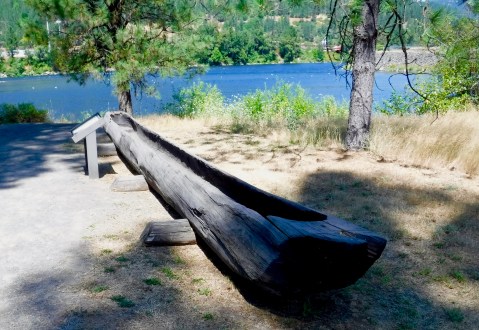
Another 30 miles down the road, I spied an historic marker located at the “Canoe Camp” where the Corps members and the helpful Nez Perce built the pine canoes destined for the Pacific Ocean. So, I missed Weippe Prairie but saw where they built and launched the canoes. And Canoe Camp was next to an asphalt road.
One final stop for the day at the National Park Service Nez Perce National Park headquarters. While there I picked up several brochures and maps for the Nez Perce National Historic Trail which follows the route of the 1877 flight from the army. I think I see another road trip in my future.
The day started out cool but it was 100 degrees when I pulled into Lewiston, Idaho, across the Snake River from Clarkston, Washington. To my delight, the Hell’s Canyon Harley-Davidson store was on the same road I was on, so I stopped in to get a Harley-Davidson t-shirt. The other one I brought with me is starting to smell.

So hard to grasp what those men went through to complete their discovery of the western territory! I see you are packing even lighter these days! Enjoy the new shirt. Ride safe.