
MHT Day 20: From Confluence to Confluence
From October 11 to October 16, 1805, the expedition paddled 154 miles downstream, overcoming several treacherous rapids along the way, in their five dugout canoes plus one canoe with two helpful Nez Perce guides from the confluence of the Clearwater and Snake Rivers at present-day Lewiston, Idaho, to the confluence of the Snake and Columbia Rivers at present-day Pasco, Washington. What they saw then is what I saw today. Not much.
With temperatures in the 90s much of the ride and reaching 100° by the time I reached Pasco, a little shade along the way would have been nice. But that would have required trees. And there weren’t any. Nor were there any when the Corps made its downstream run on the Snake River in 1805. Three days after leaving the Clearwater River, Captain Clark noted in his journal that, with the acquiescence of their two Nez Perce guides, the lack of any trees made them do something they would have preferred not to at a temporarily uninhabited Indian fishing camp.
we have made it a point at all times not to take any thing belonging to the Indians even their wood. but at this time we are Compelled to violate that rule and take a part of the Split timber we find here bured for fire wood, as no other is to be found in any direction.
The next day, Sergeant Gass added a similar comment in his journal, noting that “we had great difficulty in procuring wood to cook with, as none at all grows in this part of the country.”
What I did see, for the first 100 or so miles as I headed west, was rugged, sometimes rocky, treeless prairie grassland, followed by miles and miles of wheat and hay fields being harvested by teams of huge tractors and harvesters, clearly not a family farm operation. At one point, I passed a parade of green agrotechnological behemoths lumbering in the opposite direction looking for a fertile field to ravage; it was a good thing I was on a motorcycle because there wouldn’t have been room for these giant machines and a car on the narrow road at the same time. When I got to within 30 miles of Pasco the temperature dropped a few welcome degrees and a couple miles later the wheat fields were replaced by fecund orchards, fructuous vineyards and a few hopeful fields of hops.
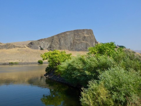
Swallow Rock, so named for the thousands of swallows that build nests there, sits across the Snake River from the Hells Gate State Park.
I began the morning in Lewiston/Clarkston by visiting a small Lewis and Clark Interpretive Center at Hells Gate State Park in Idaho. While the displays were limited, they did have one of the best short videos I’ve seen of the Expedition, focusing on the time the Corps spent between the Bitterroot Mountains and the Pacific Ocean and the aid provided to the Corps by various native tribes, including the Nez Perce. Without exception, I think, each time I visit one of these small museums or interpretive centers I learn something new. Today, for example, I learned that when the captains and enlisted men wrote their daily observations and occurrences in their journals, they used powdered ink which, when mixed with water, gave them the indelible medium they needed for their quill pens and for posterity. Not earth shattering, I realize, but this minor details helps me develop a more complete picture of the Expedition.

This osprey at Hells Gate State Park was looking for breakfast when he turned his head to look at me.
Knowing today’s ride wasn’t going to be a long one and based on a breakfast conversation with other bikers, I took a 20-mile detour before leaving Clarkston to ride what is referred to locally as the “Spiral Highway,” an old section of U.S. 95 with 64 turns in its eight-mile, 2,000 foot climb up Lewiston Hill. Very few guardrails line the shoulder to ensure careless motorists (or bikers) don’t go sliding down the hill. Unfortunately, the road was covered with “tar snakes,” an asphalt sealer used for crack repair that produces significantly dangerous traction challenges for two-wheelers, and I had to moderate my speed considerably, especially going into each of the 64 turns. One final note: It’s said this precipitous grade inspired the 1955 rockabilly hit “Hot Rod Lincoln.” That’s probably as important to know as that the Corps used powered ink. But there you have it.
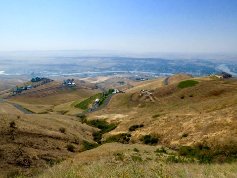
Sections of the “Spiral Highway” can be seen in the foreground. Running through the middle of the photo is the Clearwater River, to the right is the Snake River.
When Lewis and Clark reached the confluence of the Snake and Columbia Rivers, several hundred Yakima and Wanapam Indians greeted them, singing and dancing and providing “eight fat dogs and Some fresh sammon” for dinner. This was not the first time during the expedition the men had hot dogs for dinner; over the course of the trip they consumed, according to one count, more than 200 dogs, which they preferred over fish or horse meat.
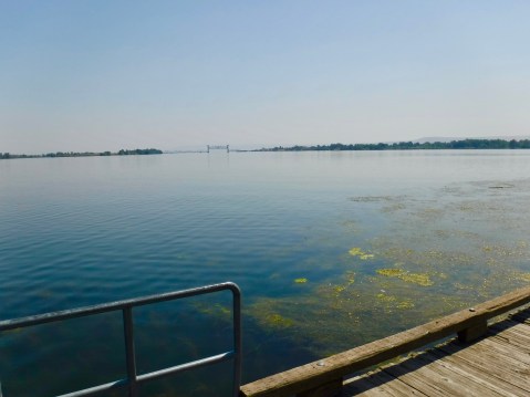
Because the Snake and Columbia Rivers are so wide where they meet, it’s hard to get a good photograph. I’m standing on the point where the two rivers merge. To the right is the Columbia River; to the left is the Snake.
When I reached the confluence of the same rivers, on the other hand, I was greeted by a locked door at the Sacajawea State Park Museum. Seems they’re closed on Monday and Tuesday. If anyone’s wondering, I had a club sandwich for dinner.
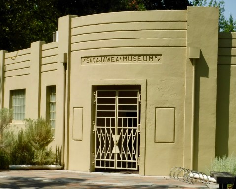
A locked door kept me from seeing what the Sacajawea Museum in Pasco had to offer.
Tomorrow I work my way down the Columbia toward the Pacific Ocean. I’ve just about reached the half-way point of this adventure.

The Spiral Highway seems to have been the days’ highlight. Hopefully a better dinner tonight! Ride safe.
I too would rather have a club sandwich.
I’m guessing powdered ink would be very challenging when writing a blog.
I’ve been on the Spiral Highway, not on two wheels but four, while visiting my little sister in Lewiston. It’s a neat road. Enjoy and be safe out there.
Big rivers, amazing country.
By the way I won’t tell Denise about the 200 dogs if you don’t tell