
MHT Day 4: Camp River Dubois–The Expedition’s Starting Point
On December 12, 1803, William Clark and the men he and Captain Lewis had gathered, landed on the eastern shore of the Mississippi River across from the mouth of the Missouri River a few miles north of St. Louis where the “Riviere Dubois” or Wood River emptied into the Mississippi. For the next five cold months, that would be their home as they added new members to the expedition and morphed from a group of disparate frontier individuals into a cohesive 28-member military unit under the command of Captains Lewis and Clark and three sergeants appointed from the ranks.
A rebuilt Fort Massac, located about 50 yards from the original (and archaeologically-important site. Unfortunately, all these buildings have been closed because they’re deemed unsafe.
My ride today generally followed the route they took, beginning at Fort Massac State Park at Metropolis, Illinois, down the Ohio River to the confluence with the Mississippi at Cairo, Illinois, (pronounced “care-o”) and then north to the Lewis and Clark Memorial State Park where the state of Illinois built and developed a Camp River Dubois interpretive center as part of the park. I say “generally followed” because my planned route on Illinois Highway 3 was cut short by “Road Closed” signs thanks to the continuing disruptions caused by this year’s flooding throughout the Midwest. Highway 3 is part of “The Great River Road,” a collection of scenic roads that run the length of the Mississippi and I was looking forward to seeing what the Illinois section had to offer. Instead, I rode through the searing heat wave scorching the county looking at some nice Illinois farmland, but it was not the view I had hoped for. In addition, my effort to stand on the point where the Ohio and Mississippi rivers join forces was also scotched by flooding that had closed the road into Fort Defiance State Park which contains said point.
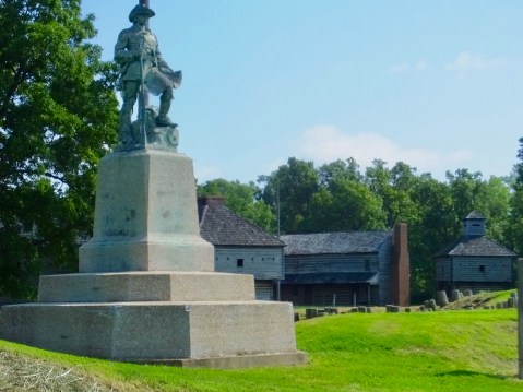
A statue of George Rogers Clark sits on the site of the original Fort Massac.
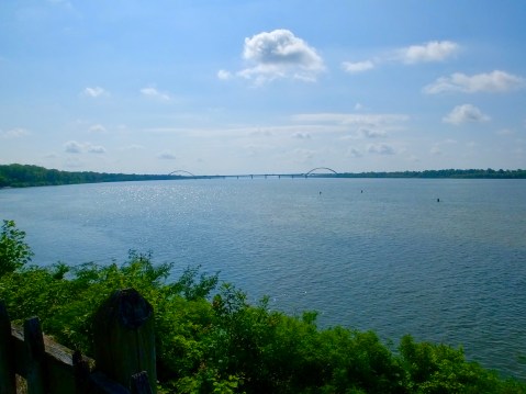
If the statue of George Rogers Clark could see from his position on the bluff above the Ohio, this would be his view. The bridge is I-24 and Paducah is on the other side.
I arrived at Fort Massac about 9:30, half an hour before the museum and visitor’s center opened and had time to look around the site which sits on a small bluff above the 3/4 mile wide Ohio River. The historic site is located in a state park which has campgrounds, picnic areas, a very busy disc golf course, and hiking trails (when it’s not underwater).
Fort Massac’s historical importance is much more than the two-day visit by Lewis and Clark, in November 1803. Its history dates to the early 16th century when Spain first claimed the area, followed by French trading and military interests in the mid 18th century before France ceded it to Great Britain in 1764 following the end of the French and Indian War. During the American Revolution, General George Rogers Clark (William Clarks older brother) used the destroyed Fort Massac in 1778 as his jumping off point for securing all of the western territory for the rebelling British colonies. George Washington ordered the fort rebuilt in 1794, and when Lewis and Clark stopped there in 1803, it held less than 100 soldiers, two of whom plus the civilian George Drouillard eventually joined the Corps of Discovery.
When Lewis and Clark’s mini-flotilla reached the confluence of the two great rivers, they halted for six days (November 14-20, 1803) during which time William Clark took a crash course in celestial navigation (using the sun, moon and stars to determine latitude and longitude). These skills proved vital to his role as the expedition’s chief cartographer, as he mapped the northern reaches of the Louisiana Purchase and the unclaimed land between the northern rockies and the Pacific Ocean. His published maps guided early settlers and explorers for decades as whites moved into the area to trap, hunt and settle.
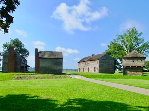
At Lewis and Clark Memorial State Park, east across the Mississippi and a few miles north of St. Louis, I took a welcome respite from the oppressive heat (index about 110) in the air-conditioned comfort of the visitor’s center. A brief movie about the Corps’ stay at Camp River Dubois confirmed what I had read last winter in the journals. But the displays were especially helpful in fleshing out my understanding of their living conditions, both at Camp River Dubois and aboard the 55-foot keelboat. The interpretive center has a unique full-size cut-away model of the boat which demonstrates how they were stored and moved several tons of supplies, food, trade goods, and tools necessary for various trades. Outside the visitor center were examples of the crude log huts they hurriedly built in December of 1803 and in which they lived 9-men to a hut.
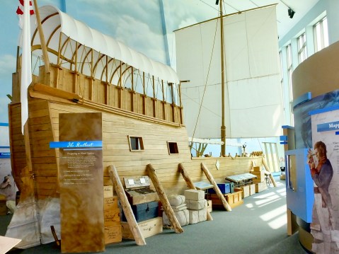
The cutaway replica of the keelboat dominates the exhibit space inside the interpretive center.
Toward the end of my visit I talked with one of the staff who turned out to be the park superintendent and who had been there since the site opened in 2002. Historian Brad Winn, as it turned out, answered several questions I had about the expedition, and then we began talking about his recent cross-county trip that followed much the same route I’ll pursue during the next three weeks. In his office, he showed me an excellent collage containing a map, pictures from the trip and a copy of the National Park Service road signs designating the Lewis and Clark trail. Unfortunately I met Brad only 15 minutes before the building closed; I would liked to have spent more time picking his brain about expedition minutia.
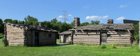
Replicas of the log huts hurriedly built by men anxious to escape from the freezing temperatures in the winter of 1803-1804.
One of the things we discussed concerned the exact location of the original Camp River Dubois. During the past 200 years, all three of the rivers involved (Mississippi, Missouri and Dubois/Wood) have shifted location by as much as three or four miles. Clark, for example, drew maps showing the Missouri and the Wood rivers directly across from one another. Today, the Wood River empties into the Mississippi several miles north of where it did in 1803. And the Mighty Mississippi has also shifted its banks about one mile to the east. In short, the original camp site, once on the eastern bank of the Mississippi, now lies either somewhere on the western shore or, perhaps, even underwater in the great river itself. We can write the history of the beginnings of the Lewis and Clark expedition without knowing exactly where they set up camp. But it sure would be nice to know for sure.
The Corps spend five months in the vicinity of St. Louis. The least I can do is spend an extra day here learning a little more about their beginnings by visiting several key interpretive centers, which is what I’ll do tomorrow.
MHT Day 3 (?): On the Road. Again.
I finally now seem to be securely on the road, though the early days of the Magical History Tour have been fraught with motorcycle-related delays. Yesterday, I picked up the bike in Morristown after a new stator and new voltage regulator installed by the technicians at Colboch Harley-Davidson remedied the electrical issues that delayed my progress for three days. My destination, as I rode the hills of eastern Kentucky and admired some of the state’s smaller horse farms, was Clarksville/Louisville, where Clark joined Lewis and his growing band of adventurers in 1803 for the final leg down the Ohio River and up the Mississippi River to St. Louis.
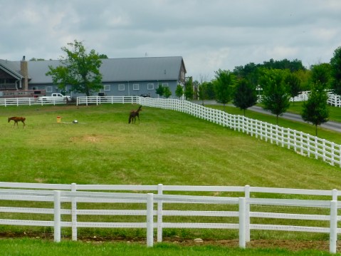
There were bigger horse farms in Kentucky but this one caught my eye and had a safe place to pull off and get a picture for Sue in South Carolina.
About 30 miles from my destination yesterday, I experienced a problem I associated with a slipping clutch. Although I continued to ride the bike through the 95 degree temperatures to the day’s target, I wasn’t sure what the problem was nor whether the bike could go another 8,500 miles without leaving me stranded. So I tracked down the local Harley dealer, detoured to the store and pled my case for quick attention to the service writer. By the time I arrived at the store, it was nearly 3 p.m. and the service department was backed up with Harleys in need of repair. But, convinced of my importunate desire to continue my westward quest to the Pacific, the service writer said she would schedule my bike first thing this morning to determine what mischievous gremlins were messing with my clutch.
I didn’t post a blog last night because I didn’t know what to write. I had seen nice country but hadn’t made the L&C historical stop that I planned for Louisville. And I didn’t know what to say about how long the trip might be delayed again. So I waited until today to resume writing.
When I rode the bike to the dealership this morning, I tried to reproduce the issue I experienced yesterday, but–and this is good news–I couldn’t make the clutch slip even when I duplicated yesterday’s conditions as nearly as I could. What was different? Yesterday the temperature was in the mid 90s and this morning it was 20 degrees cooler. Perhaps, I thought, the problem was, at least in part, heat related. But even though the problem wasn’t recurring I decided to have the bike checked out by Donnie, the Master Technician at Bluegrass Harley-Davidson. After multiple mechanical surprises over the past two weeks, I should be pardoned if I’m a little gun shy.
When they opened the service door I drove in and the technician went through his paces. An hour and a half later, he reported that he couldn’t find an obvious problem, though he did tighten the clutch cable and made a couple other adjustments. He said the bike should be good for my proposed cross-country jaunt. I paid my bill, saddled up and hit the road at noon for Paducah, Kentucky, along the banks of the Ohio. One final note about today’s visit at Bluegrass Harley-Davidson. While I was waiting in the service area, John Dunn, former service writer at Adamecs in Orange Park, FL, where I bought the very bike that was then in for repair called my name and reintroduced his still-bearded self. He is the service manager at Bluegrass and just as he took care of me in Florida, he did the same in Kentucky. Small world.
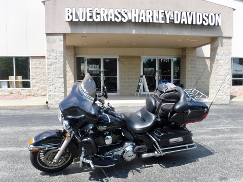
Repaired AGAIN and ready for the road thanks to the folks at Bluegrass Harley-Davidson.
Today was another day in the mid-90s, but unlike the previous two riding days there were no mechanical issues, no furtive sounds, no surprise jerks or jolts, no warning lights. Just smooth sailing. At last.
Because of the four-hour repair delay, I didn’t have time today to visit any historic sites, but I did cross the Ohio river that carried the expedition in 1803 three times today. It’s breadth and depth must have been a welcome relief to Lewis after his painfully long voyage over shoals and rapids from Pittsburg to Clarksville. I did have time after checking in to my motel and cooling off for a few minutes to ride to the river and take a long, contemplative look at this vital and historic waterway.
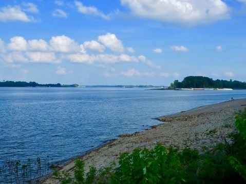
The Ohio River at Paducah. To the right, the Tennessee River joins the much larger Ohio. The Ohio presented some early problems for Lewis, but at least he was going with the current. When he reached the Mississippi his crew was rowing upstream. Good practice since they would be rowing or paddling upstream on the Missouri for many months.
Lewis and Clark stopped for several days across the river from present-day Paducah at Fort Massac in mid-November 1803. Their most important acquisition at the fort was a hunter/interpreter name George Drouillard, the son of a French-Canadian father and Shawnee mother. Neither Lewis nor Clark ever learned to spell his name correctly, usually using “Drewyer” when referring to him in their journals. Drouillard was one of only five civilians among the 33-member party who made the journey to the Pacific and back and proved to be the most reliable hunter on the expedition as well as a skilled user of sign language among plains Indians.
While I was enjoying the view of the Ohio from the banks of downtown Paducah I noticed something completed unrelated to this trip but of great interest to Marilyn back in Maggie Valley. So I took a picture of the National Quilt Museum just so she can add it to her future travel adventures.
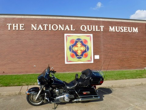
I see another trip to Paducah in my future.
Tomorrow, I’ll begin with a stop across the river at historic Fort Massac, then continue down the Ohio to the confluence with the Mississippi, then turn north and follow the great river to St. Louis. The day is expected to be hot again as a vicious heat wave swallows middle America but, hopefully, there will be no mechanical mishaps to report. It’s good to be on the road again.
MHT Day 2: Disappointment not Despair
When I posted last night, I optimistically suggested the electrical issues with my bike would be remedied in short order and I would be on the road again in a day or two at most. This morning, the service manager at the Harley dealership in Morristown called to say that the earliest they might be able to diagnose and work on the problem would be Wednesday, but more likely would be Friday. He added that if they had any cancellations of previously scheduled jobs they would try to work me in, but he didn’t expect that would happen. It’s a small service department–only two or three technicians–and summer is peak riding season; I understand their inability to focus their attention on one impatient old rider who is extremely anxious to start logging miles again.
So, to my great chagrin, I’m hitting the reset button for this trip and will resume it just as soon as my Harley is road-worthy. I’m hopeful that will occur Friday or Saturday, but the timing of the re-launch is out of my hands. I’m not unpacking my bags and I remain primed and ready to restart my one-person, cross-country expedition at the earliest moment.
During their historic journey across America, the Corps of Discovery experienced countless disappointments, delays and detours, but they persevered, proceeded and overcame myriad difficulties. I will do the same.
I won’t post again until I’m on the road or I have word that I’ll be on the road the next day. For those who signed up for email notices when a post is made, you will know when the adventure recommences. If you haven’t signed up for email notices, please consider that. Or you can check back every few days to see if I’m rolling again. Sorry for the disruption in the blog, but I’ll be back to reporting on the Magical History Tour soon.
MHT Day 1: The Best Laid Plans…
When Captain Lewis left Washington, D.C., on July 5, 1803, he had a pretty good idea of the schedule he planned to keep on his way to the Pacific and expected to be hundreds of miles up the Missouri River west of St. Louis before cold and ice halted the Corps of Discovery. In the spring of 1803, during visits to Philadelphia and Harpers Ferry, he ordered supplies to be delivered to Pittsburgh, where the Ohio River is born of the joining of the Allegheny and Monongahela Rivers and where he had contracted for a 55-foot keelboat to be built and ready by July 20. He arrived in Pittsburgh July 15 only to discover the keelboat was nowhere near ready and the drunken shipbuilder in charge had a boatload of excuses but no boat. Lewis had tons of supplies waiting to move downstream, he enlisted three men who would become part of the permanent party plus several more adventuresome souls to help transport his supplies down the Ohio, and then he waited. And waited. On August 31, a month and half after he reached Pittsburgh, he and his crew finally launched their craft on an Ohio River woefully short of water, which made moving a keelboat with a three-foot draft a frustratingly time-consuming challenge.
A month and a half later, on October 14, Lewis and his group reached Captain Clark in Clarksville, Indiana, across the river from Louisville, Kentucky. Lewis must have been anxious to press on, but the group, now grown to more than a dozen with the addition of at least seven men chosen by Clark, delayed leaving Clarksville until October 26 and didn’t reach the confluence of the Ohio and Mississippi Rivers until November 20. After rowing upstream for more than three weeks, on December 12 they ultimately reached their destination on the Mississippi River across from the mouth of the Missouri River and a few miles upstream from St. Louis. There they would stay for five months, enlisting and training new recruits for the Corps of Discovery and preparing for a spring 1804 start up the Missouri on their voyage across territory that now officially belonged to the United States thanks to the recently ratified treaty confirming the Louisiana Purchase.
Despite years of preparation, Lewis’ plan to be several hundred miles further west before stopping for winter had been upset by numerous delays over which he had little or no control. Isn’t that the way things usually work out?
I mention all of this historical background to help put in perspective today’s travels.
Prepared and packed for an early departure.
After years of planning and months of preparing, I rolled out of my driveway this morning a little before 8 a.m., ready for a 350-mile ride through Kentucky to Clarksville, Indiana, where Lewis and Clark had joined forces in the fall of 1803. A little rain splattered my windshield as I passed through the northeast corner of Tennessee, but not enough to be of concern or to slow me down. I had a schedule to keep. I had plans.
About 10:30 a.m. and two miles from the Kentucky border, I glanced at my gauges and noticed, to my great dismay, that the check engine light and the battery light were both illuminated and the voltage gauge was reading 11 volts when it should have been reading 14. I crossed the border at Cumberland Gap, braked to a stop a mile or two later in Middlesboro, and began assessing my sorry situation. I suspected it was a stator (think alternator) gone bad or the voltage regulator. In either case, I knew I couldn’t ride the bike far because the battery would eventually die and I’d be stuck on the side of the road. The fact that today is Sunday and that Middlesboro doesn’t boast a Harley-Davidson dealership severely limited my options to get back on the road quickly.
I had noticed a Harley dealer about an hour earlier as I whizzed through Morristown, Tennessee, and a quick internet search showed that Colbochs Harley-Davidson was indeed the nearest source of help. The dealership was open from 12 to 5 but the service department wouldn’t open until tomorrow at 9 a.m. At noon I called the dealership to see if anyone there could help transport my bike 45 miles back to their shop. They didn’t have anyone who fit that bill, but Ernie, the sales manager, went above and beyond and made some calls until he found a towing service that would come to Middlesboro, pick up my bike and me, and deliver us to the dealership. Arrangements were made and a driver with a roll-back truck was promptly dispatched.
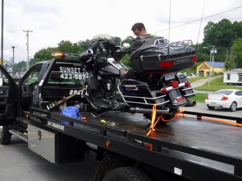
There is no sorrier sight than a Harley Davidson on a roll-back truck.
That solved part of my problem. Now I had to figure out where I was going to spend the night. A series of conversations with Marilyn resulted in her driving 75 miles to Morristown to pick me up and take me back to Maggie Valley, where I currently sit sipping a well-deserved glass of Jack Daniels, pondering the annoying vagaries of travel in the 19th and 21st centuries. Tomorrow, if Ernie is true to his word–and I have no reason to think he won’t be–Colboch’s crack service department will dismantle my aged bike first thing, remove bad things and install good things, and get me on the road again ASAP. I’m hopeful their call to me tomorrow morning will be good news and that I can pick the bike up early in the afternoon, and, like Captain Lewis two centuries before me, continue my unexpectedly delayed trip to St. Louis. If not tomorrow, then an early Tuesday delivery will still get me to St. Louis Tuesday evening after 10 hours and 550 miles on what will probably be wet roads thanks to the rainy remnants of Hurricane Barry.
I’ve said before that these trips are adventures not vacations. But I didn’t expect this adventure to start producing the unexpected so quickly. Stay tuned to see what further misadventures enhance the Magical History Tour.
By the way, for those who follow the blog just to see what pie I eat, today’s pie was leftover cheesecake at home. And yes, cheesecake is technically pie.

Magical History Tour (MHT): Prologue
In the spring of 1801, 57-year old Thomas Jefferson, newly elected third President of the United States, asked 28-year old Captain Meriweather Lewis to become his private secretary. No one is quite sure why he chose Lewis, but Jefferson’s long-term dreams and plans for the western portion of North America must have played a role. During the next two years, while European intrigue boiled around them, the two Virginians talked at length about exploring the un-explored West. As construction crews continued work building the “President’s House” (aka The White House), the new president and his young protégé poured over existing maps and descriptions of the largely unknown American west and put in motion a plan to explore and stake the new nation’s claim to it.
By 1803, efforts were underway to secure for the United States land claimed by France east of the Rocky Mountains and west of the Mississippi River, culminating in what we know today as the Louisiana Purchase. At the same time, Jefferson and Lewis had developed the outlines of a western expedition, and Lewis began to make specific plans to form, outfit, and assume command of what became known as the Corps of Discovery.
Lewis, without hesitation, asked that 32-year old William Clark, with whom he had served in the army on the frontier several years earlier, be assigned as his co-equal in the adventure. These two young army officers and 30 some other enlisted men and civilians would spend the next three years living an early and crucial chapter in American history as they searched for the headwaters of the Missouri River, looked for a feasible water/land route to the Pacific, expanded scientific knowledge by identifying hundreds of previously unknown plants and animals, and established relationships with native peoples whose ancestors had lived in the area for thousands of years.
During the next five to six weeks, I’ll once again expand my geographic and intellectual horizons by retracing the route of the 1804-1806 Lewis and Clark Expedition, up the Missouri River to its source in Montana, over the Rocky Mountains to the land of the Nez Perce Indians (aka Niimiipuu) in Idaho and down the Snake and Columbia Rivers to the Pacific coast at present-day Astoria, Oregon. Along the way, as I navigate my well-traveled Harley-Davidson on scenic and lonely backroads that parallel their mostly-water route, I’ll visit historic sites, explore museums large and small, catch glimpses of the wild and rugged lands they traversed, and learn more about their incredible journey. And I’ll share my journey—and theirs—through daily blog postings and pictures. I’m glad you’re reading this and hope you follow along in the coming weeks as I joyously pursue two passions that have occupied much of my adult life: motorcycling and history.
For those who followed my two-wheeled rambling via earlier blogs (e.g. Alaska, Newfoundland, the Rocky Mountains, Alaska again), welcome back. For newcomers, know that I’ll try to entertain you for a few minutes each day with various misadventures, serendipitous encounters with interesting people, and pictures of our beautiful land and its amazing inhabitants. During this year’s great adventure, I’ll include a little more history than in past blogs. Please feel free to use the comments section of the blog to stay in touch, respond to my ramblings and let me know what you think about this year’s Magical History Tour.
Tomorrow it begins. “I can’t wait to get on the road again.”
Partial Cast of Characters: The Queue Crew
ROUTE MAP: Click here for a PDF map of the entire Corps of Discover route. This map opens in a new window.
