
MHT Day 4: Camp River Dubois–The Expedition’s Starting Point
On December 12, 1803, William Clark and the men he and Captain Lewis had gathered, landed on the eastern shore of the Mississippi River across from the mouth of the Missouri River a few miles north of St. Louis where the “Riviere Dubois” or Wood River emptied into the Mississippi. For the next five cold months, that would be their home as they added new members to the expedition and morphed from a group of disparate frontier individuals into a cohesive 28-member military unit under the command of Captains Lewis and Clark and three sergeants appointed from the ranks.
A rebuilt Fort Massac, located about 50 yards from the original (and archaeologically-important site. Unfortunately, all these buildings have been closed because they’re deemed unsafe.
My ride today generally followed the route they took, beginning at Fort Massac State Park at Metropolis, Illinois, down the Ohio River to the confluence with the Mississippi at Cairo, Illinois, (pronounced “care-o”) and then north to the Lewis and Clark Memorial State Park where the state of Illinois built and developed a Camp River Dubois interpretive center as part of the park. I say “generally followed” because my planned route on Illinois Highway 3 was cut short by “Road Closed” signs thanks to the continuing disruptions caused by this year’s flooding throughout the Midwest. Highway 3 is part of “The Great River Road,” a collection of scenic roads that run the length of the Mississippi and I was looking forward to seeing what the Illinois section had to offer. Instead, I rode through the searing heat wave scorching the county looking at some nice Illinois farmland, but it was not the view I had hoped for. In addition, my effort to stand on the point where the Ohio and Mississippi rivers join forces was also scotched by flooding that had closed the road into Fort Defiance State Park which contains said point.
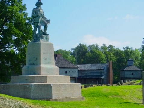
A statue of George Rogers Clark sits on the site of the original Fort Massac.
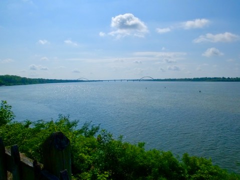
If the statue of George Rogers Clark could see from his position on the bluff above the Ohio, this would be his view. The bridge is I-24 and Paducah is on the other side.
I arrived at Fort Massac about 9:30, half an hour before the museum and visitor’s center opened and had time to look around the site which sits on a small bluff above the 3/4 mile wide Ohio River. The historic site is located in a state park which has campgrounds, picnic areas, a very busy disc golf course, and hiking trails (when it’s not underwater).
Fort Massac’s historical importance is much more than the two-day visit by Lewis and Clark, in November 1803. Its history dates to the early 16th century when Spain first claimed the area, followed by French trading and military interests in the mid 18th century before France ceded it to Great Britain in 1764 following the end of the French and Indian War. During the American Revolution, General George Rogers Clark (William Clarks older brother) used the destroyed Fort Massac in 1778 as his jumping off point for securing all of the western territory for the rebelling British colonies. George Washington ordered the fort rebuilt in 1794, and when Lewis and Clark stopped there in 1803, it held less than 100 soldiers, two of whom plus the civilian George Drouillard eventually joined the Corps of Discovery.
When Lewis and Clark’s mini-flotilla reached the confluence of the two great rivers, they halted for six days (November 14-20, 1803) during which time William Clark took a crash course in celestial navigation (using the sun, moon and stars to determine latitude and longitude). These skills proved vital to his role as the expedition’s chief cartographer, as he mapped the northern reaches of the Louisiana Purchase and the unclaimed land between the northern rockies and the Pacific Ocean. His published maps guided early settlers and explorers for decades as whites moved into the area to trap, hunt and settle.
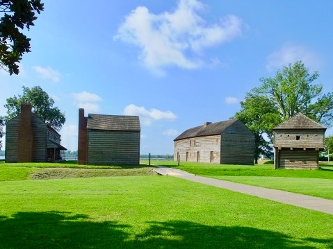
At Lewis and Clark Memorial State Park, east across the Mississippi and a few miles north of St. Louis, I took a welcome respite from the oppressive heat (index about 110) in the air-conditioned comfort of the visitor’s center. A brief movie about the Corps’ stay at Camp River Dubois confirmed what I had read last winter in the journals. But the displays were especially helpful in fleshing out my understanding of their living conditions, both at Camp River Dubois and aboard the 55-foot keelboat. The interpretive center has a unique full-size cut-away model of the boat which demonstrates how they were stored and moved several tons of supplies, food, trade goods, and tools necessary for various trades. Outside the visitor center were examples of the crude log huts they hurriedly built in December of 1803 and in which they lived 9-men to a hut.
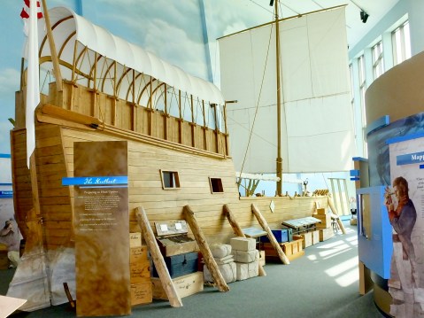
The cutaway replica of the keelboat dominates the exhibit space inside the interpretive center.
Toward the end of my visit I talked with one of the staff who turned out to be the park superintendent and who had been there since the site opened in 2002. Historian Brad Winn, as it turned out, answered several questions I had about the expedition, and then we began talking about his recent cross-county trip that followed much the same route I’ll pursue during the next three weeks. In his office, he showed me an excellent collage containing a map, pictures from the trip and a copy of the National Park Service road signs designating the Lewis and Clark trail. Unfortunately I met Brad only 15 minutes before the building closed; I would liked to have spent more time picking his brain about expedition minutia.
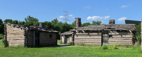
Replicas of the log huts hurriedly built by men anxious to escape from the freezing temperatures in the winter of 1803-1804.
One of the things we discussed concerned the exact location of the original Camp River Dubois. During the past 200 years, all three of the rivers involved (Mississippi, Missouri and Dubois/Wood) have shifted location by as much as three or four miles. Clark, for example, drew maps showing the Missouri and the Wood rivers directly across from one another. Today, the Wood River empties into the Mississippi several miles north of where it did in 1803. And the Mighty Mississippi has also shifted its banks about one mile to the east. In short, the original camp site, once on the eastern bank of the Mississippi, now lies either somewhere on the western shore or, perhaps, even underwater in the great river itself. We can write the history of the beginnings of the Lewis and Clark expedition without knowing exactly where they set up camp. But it sure would be nice to know for sure.
The Corps spend five months in the vicinity of St. Louis. The least I can do is spend an extra day here learning a little more about their beginnings by visiting several key interpretive centers, which is what I’ll do tomorrow.

Very informative about the beginnings of their adventure and unfortunate regarding the heat and flooded roads! Stay hydrated and ride safe!
You are such a great writer…
Impressed that despite mechanical setbacks, road closures, and the heat, your not discouraged! Love the Blog!!!
Did you go through old Cairo ? Kinda sad all abandoned.
So what is the relationship between Dubois River and the Wyoming town
of Dubois’s near the Wind River Range ?