
MHT Day 11: Notes on Natives
On the evening of September 24, 1804, the expedition, having gone 13 miles up the Missouri River that day, encamped a couple hundred yards from where I encamped last night at the Holiday Inn Express in Ft. Pierre, SD. The next day, during a meeting between the expedition and the Teton Sioux, trouble arose when a lesser chief believed he had been slighted in the exchange of gifts and several Teton attempted to seize one of the small pirogues. The fracas, alarming at the time, didn’t amount to much and ultimately the Captains and several other crewmen were feted by the Sioux in their camp and continued their voyage upriver the next day with scores of Indians following along on the bank. Although no further serious confrontation erupted, the crew and captains were pleased to leave the troublesome Sioux behind.
Most of the Indians the expedition met were friendly and helpful, but the Sioux were a different matter. The Sioux harassed, raided and warred on neighboring tribes, stealing provisions and taking women and children captive. On both the outward and return legs of their journey, some of the Sioux presented problems for the expedition, a development Lewis and Clark had expected before setting out from St. Louis.
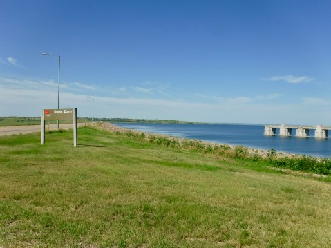
Oahe Dam and Lake north of Pierre, SD
The river where the Teton Sioux encounter occurred is very much changed from when the Corps of Discovery saw it. The building of the Oahe earthen dam just north of Pierre (pronounced “peer”), South Dakota’s capital city changed everything. Going east to west, the Oahe is the third in a series of six dams which have forever altered the Missouri River. Today, I rode more than 200 miles parallel not to a river, but to a very long lake full of weekend pleasure boaters and anglers. And the three biggest lakes are still ahead of me.
The proposal for six dams was made as part of a comprehensive flood control and hydroelectric project in 1944 and the Oahe Dam was completed in 1962, flooding hundreds of thousands of acres and displacing Sioux living on the Standing Rock Indian Reservation, as well as other Indians on other reservations. Not only were more than 50,000 acres taken from them, the land that was flooded was among the best agricultural land on the reservation. They were promised compensation but it never materialized and in 2019 the Sioux are still fighting to be properly reimbursed for the theft of their land.


The Sioux and other tribes Lewis and Clark met in 1804 and 1806 were relative newcomers to this land, having migrated to it from the east and the north beginning about 350 years ago. The land had been inhabited by nomadic Indian peoples for thousands of years, perhaps as many as 12,000 years ago, and evidence of them has been found in hundreds of archeological digs. Years before Lewis and Clark arrived, the natives had already suffered calamitous setbacks to their lives and culture, mostly through the introduction of smallpox and other devastating diseases brought by French and Spanish explorers and traders.
A good example of this effect is seen in the Mandans, who occupied the area near where I finished today’s ride at Bismark, ND. At a stop at Abraham Lincoln State Park, about 25 miles from the North Dakota state capital, I toured a site mentioned by Clark who wrote about it on October 20, 1804.
I saw an old remains of a villige on the Side of a hill which the Chief with us Too né tels me that nation (Mandans) lived in a number villages on each Side of the river and the Troubleson Seauex caused them to move about 40 miles higher up where they remained a fiew years & moved to the place they now live
The site, covering 6 to 8 acres with archaeological evidence of at least 68 family dwellings and a large council lodge, is known as On-A-Slant village because of its position on the side of a hill overlooking the Missouri River. When Clark and others of the expedition saw the remains of the village, it had already been abandoned and burned by the Mandans. Why? Because after a devastating smallpox epidemic swept through it in the 1790s there were no longer enough men left to defend those who survived the disease from raids by their Sioux neighbors to the south. So the remaining members of the tribe packed up and moved north where they were joined by Arikara survivors of their own smallpox epidemic.
As a side note, about 1/2 mile from On-A-Slant village, the U.S. Army built a fort and then a cavalry post in the years after the Civil War. At one time the post was commanded by Lt. Col. George A. Custer, but he went on a military expedition in 1876 and never returned. Fort Abraham Lincoln State Park contains both the On-A-Slant Village site and the Fort and both were partially reconstructed by the Civilian Conservation Corp (CCC) during the 1930s.
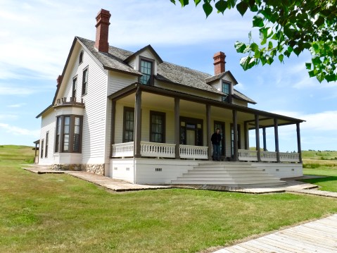
A lone soldier stands guard on the porch of Lt. Col. George Custer’s reconstructed house.
I had planned to go to another site today in Bismarck at the North Dakota State Museum but ran out of time. A road sign on SD 1804 north of Mobridge indicated the road was closed to trucks 23 miles ahead. But 23 miles later when I got to that point the road was closed to all traffic, so I had to backtrack, losing an hour in the process. But at least today wasn’t as hot as yesterday and the scenery of rolling hills and high wispy clouds was enjoyable.

Amazing how poorly the original settlers of the land have been treated over the many years! Ride safe.
Very interesting and tragic history of the Indians in that area.
Great stuff again today!