
MHT Day 24: The Return East Begins
For five weeks after the Corps bid adieu to Fort Clatsop, they paddled and pulled against the current, up the Columbia River, portaging around various falls and rapids as they went. Three weeks after they began their eastward journey, they lost one of the canoes in the rapids and it smashed to pieces, which meant that they had to overload the remaining canoes and carry some of their baggage on their backs. What they needed were horses, and on April 15, Captain Clark made the first attempt to purchase several from Indians above the falls but failed because his short supply of stores and trade goods limited his purchasing power. What they could trade, the Indians didn’t want; what the Indians wanted–guns, kettles, iron goods–,they couldn’t trade.
On April 18, Clark finally purchased their first four horses, which were desperately needed to portage their dwindling but still substantial baggage around the great cataract at Celilo Falls (now buried by The Dalles Dam). Each day, when they encountered another group of Indians, they attempted to buy more horses. By April 20 they had eight. A few days later the number had increased to 14 and they made a like number of pack saddles to carry their stores.
Finding and buying horses wasn’t the only problem. Lewis became increasingly irritated by petty thievery practiced by Indians they encountered along the way. On April 21, he lost his temper, struck an offending Indian and had pilfered a small piece of metal and ordered the men to kick him out of the camp. That evening he wrote about Indian misdeeds, saying
they have vexed me in such a manner by such repeated acts of villany that I am quite disposed to treat them with every severyty, their defenseless state pleads forgiveness so far as rispects their lives.
A few days later they reached the point where the Columbia turns north to meet the Snake River, about 30 miles south of present day Pasco. By that time, the captains had determined to heed the advice of a Nez Perce warrior traveling east with his family back to the land where the Nez Perce had fed and cared for the starving party when they emerged from the Bitterroots the previous fall. They would leave the river and march cross country until they reached the confluence of the Snake and Clearwater rivers and reclaim the Shoshone horses they had left there the previous fall. On April 28, after noting they had purchased an additional 12 dogs to supplement their pounded fish diet during the overland march, Sergeant Ordway wrote:
our Indian guides who are going over the mountains with us inform us that their is a nearer way across the plains to the forks of Lewises river [Snake] at the entrence of Kooskooske [Clearwater] which is a Smooth way and only 3 days march to that place which is allmost as near again as to follow the river round.
For the first time since leaving Fort Clatsop, they were going to travel an uncharted route.
Since I had followed the route down the Columbia a few days ago on my way to Astoria, I thought I would make today a motorcycle ride with sight seeing detours and no museums or interpretive centers. I had missed seeing Mount Hood on the way west, so at Portland I ventured southward to get a view of the mountain which had become one of Lewis and Clark’s important landmarks.
It was cloudy (of course) in Astoria when I left this morning wearing my heavy gloves and leather jacket, and, to my chagrin, the clouds didn’t lift as I motored east. Still, I thought, maybe they’ll clear as I near Mount Hood. So, with a raging case of optimism, I sought out Mount Hood. Still cloudy when I got to Mount Hood Village and no mountain was visible. But I was committed to my detour, so I started up the grade that goes over the south shoulder of the mountain. Here is what I saw:
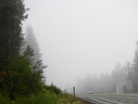
Somewhere in there is a mountain. Use your imagination.
I decided, as I rolled down the eastern slope of the shoulder that as long as I was detouring, I would leave the U.S. highway and find something a little more isolated. I saw a sign with highway numbers that I presumed indicated a county road or a forest service road. No matter. It looked inviting, so I executed a sharp right turn and headed into the alluring unknown. Here is what I saw:
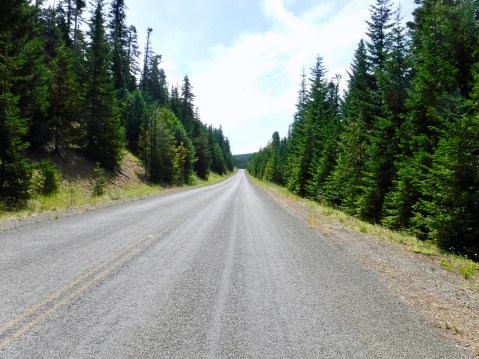
Not wilderness, but at least I was off the main road and having an adventure. And the sky was clearing.
As I putted along, a little north, a little east, a little north, a little east, I knew I was going generally in the direction I needed to go and that eventually I would probably emerge from the woods somewhere near The Dalles. There were some nice twists and turns, but the condition of the road meant keeping my speed a little lower than some adventures allow. And then I turned another corner. Here is what I saw:
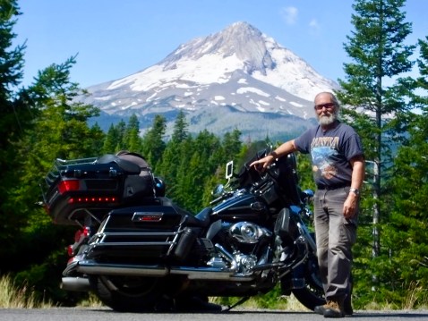
Not as much snow as I expected, but I had finally found Mt. Hood.
That discovery made my day, and the rest of the afternoon spent on the highways again went by pretty fast.
Tomorrow, I’ll go cross-country as did Lewis and Clark, back to the land of the Nez Perce.

An unexpected and stellar finish to the day. Great pic.
Never can take a bad picture when your background is a snow covered mountain! Beautiful! Ride safe.