
MHT Day 17: One Very Long River
The Missouri River is 2,341 miles long, measured from the confluence of the Jefferson, Madison, and Gallatin rives in Three Forks, Montana, to the confluence with the Mississippi River just north of St. Louis. The Big Muddy is the longest river in the United States, and it seems like it to my Harley butt. Since I left Maggie Valley, I’ve ridden 3,748 miles to get to Three Forks today, including a few planned and unplanned detours. The last two miles of today’s ride, I rode through moderately hard rain, the first time I’ve dealt with that since I started this Magical History Tour. I’ll take 16 dry days in a row, even if some of them were hot.
I also had two other firsts today. A tour boat trip through the Gates of the Mountains canyon marked the first time I’ve been ON the Missouri River this trip. The final first for the day was my first spotting of snow on the distant peaks of the Rocky Mountains looking over the Jefferson River.
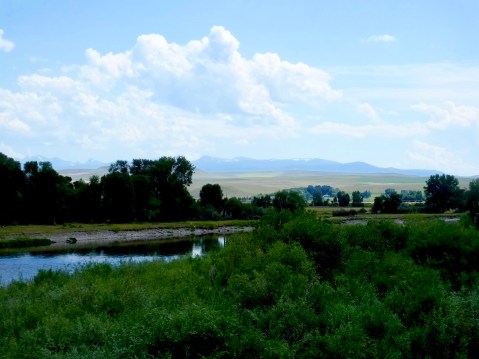
As I looked beyond the Jefferson River, which the Corps of Discovery went up in July and August 1805, I could see snow glistening at the tops of some of the distant mountains. Not big is this picture, but the white spots on the tops of the mountains are snow.
On July 19, 1805, Captain Lewis wrote in his journal about an unusual river canyon in which he was encamped for the night.
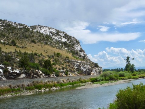
this evening we entered much the most remarkable clifts that we have yet seen. these clifts rise from the waters edge on either side perpendicularly to the hight of 1200 feet. every object here wears a dark and gloomy aspect. the tow[er]ing and projecting rocks in many places seem ready to tumble on us. the river appears to have forced it’s way through this immence body of solid rock for the distance of 5¾ miles and where it makes it’s exit below has thrown on either side vast collumns of rocks mountains high. the river appears to have woarn a passage just the width of it’s channel or 150 yds. it is deep from side to side nor is ther in the 1st 3 miles of this distance a spot except one of a few yards in extent on which a man could rest the soal of his foot. . . . from the singular appeaerance of this place I called it the gates of the rocky mountains.
Lewis’s Gates of the Rocky Mountains canyon is still there, though the presence of a dam downstream a few miles from the entrance to the canyon has raised the water level by about 18 feet. Today’s two-hour trip once again offered me a chance to see what the Corps of Discovery saw, with only a few changes. The rock walls still tower more than 1200 feet above river travelers and the canyon still inspires awe in those who pass by. Bald eagles and ospreys still soar overhead, occasionally plunging to the surface in search of a meal. Swallows still dart in and out of the canyon walls where they build their nests. The monstrous rocks still tower overhead, threatening, as Lewis noted, to tumble from their lofty perches into the cold, clear water below. Native American pictoglyphs painted by unknown shamans or artists more than a thousand years go still catch the eye of the observant voyager. Two hundred years haven’t changed this landscape much.
I was lucky once again to have found a knowledgable guide for this tour. Kari (pronounced Car ee) has been piloting tour boats, pointing out hard to find features, and relating history and stories related to the canyon for seven years. She knew how Lewis felt on entering the Gates and what he wrote about it. She told the story of the Mann Gulch Fire in the canyon in 1949 that took the lives of 13 smoke jumpers and is still used to teach fire fighting skills today. She knew the history of the first steamboat to go through the canyon. She explained the almost sacred relationship between the previous owners of the land bordering the river and the canyon. I would love to be able to spend a full day in a small boat with Kari slowly coursing through the towering canyon and hearing more of what she knows about this powerful landmark in the voyage of Lewis and Clark.
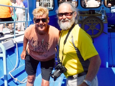
Kari shared a wealth of knowledge about the Gates of the Mountains.
Although they didn’t know it, when the men of the expedition exited the canyon they were only 90 miles and five days from the beginning of the Missouri River at Three Forks.
Clark arrived on foot at the Three Forks on July 25, having gone ahead of the main party hoping to make contact with the Shoshone (Sacagawea’s people), from whom they had to obtain horses if they were to continue their march to the Pacific Ocean. Lewis arrived by boat with the rest of the Corps on July 27 and they spent the next several days scouting, trying to determine which of the three rivers would be the real headwaters of the Missouri.
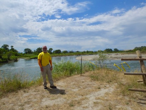
The river to the right is the Missouri; the river behind me is the Jefferson which the Corps ascended, the river to the left is the Madison. The Gallatin enters the Missouri about 1/2 mile downstream.
On July 28, Lewis recorded his and Clark’s decision to discontinue using the name Missouri to designated any of the rivers above Three Forks:
Both Capt. C. and myself corrisponded in opinion with rispect to the impropriety of calling either of these streams the Missouri and accordingly agreed to name them after the President of the United States and the Secretaries of the Treasury and state having previously named one river in honour of the Secretaries of War and Navy. In pursuance of this resolution we called the S. W. fork, that which we meant to ascend, Jefferson’s River in honor of 〈that illustrious personage〉 Thomas Jefferson. the Middle fork we called Madison’s River in honor of James Madison, and the S. E. Fork we called Gallitin’s River in honor of Albert Gallitin.
On July 27, 1805, Meriwether Lewis wrote that he ascended the point of a high limestone clift from whence I commanded a most perfect view of the neighbouring country. His vantage point was the cliff in this photograph, from which he could see all three rivers for a distance of 10 miles or more and helped him decide the Jefferson River was the river they should continue on.
By August 10,1805, the party had reached the place where I am now, Dillon, MT on the Jefferson River. On August 1 Lewis and three others made their first contact with the Shoshone and a few days after that, following an emotional meeting between Sacagawea and her brother Chief Cameahwait, they crossed the continental divide at Lemhi Pass and left the United States.
Tomorrow I’ll follow the Corps over the divide, into Shoshone country and on to the foot of the Bitterroot Range of the Rocky Mountains.

Such beautiful country, great picts as always! Ride safe.