
MHT Day 15: Decision Time
On June 2, 1805, the expedition unexpectedly came upon the junction of an unknown river with the Missouri. During the winter of 1804-1805 at Fort Mandan, the captains had spoken at length with natives and French and British trappers and traders to discover as much as they could about the Missouri River they would ascend when the ice broke. They learned about several rivers and about a waterfall on the Missouri, but no one mentioned the large river they had just encountered.
On June 3, Lewis wrote in his journal:
This morning early we passed over and formed a camp on the point formed by the junction of the two large rivers . . . . An interesting question was now to be determined; which of these rivers was the Missouri, or that river which the Minnetares . . . . had discribed to us as approaching very near to the Columbia river. to mistake the stream at this period of the season, two months of the traveling season having now elapsed, and to ascend such stream to the rocky Mountain or perhaps much further before we could inform ourselves whether it did approach the Columbia or not, and then be obliged to return and take the other stream would not only loose us the whole of this season but would probably so dishearten the party that it might defeat the expedition altogether. convinced we were that the utmost circumspection and caution was necessary in deciding on the stream to be taken.
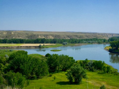
Decision Point. On the left, the Marias River flows into the Missouri. On the right, the Missouri flows downward from the Rocky Mountains on its way to the Mississippi River.
One of the readers of this blog recently asked how the captains decided they were headed in the right direction. The decision they faced on June 2 exemplifies how they made the choices they did. The party stayed for nine days at this river junction, repacking their gear, deciding what to cache when the time came to leave some of it behind, and, most importantly, sending exploring parties up both rivers on foot for several days to learn what they could. At the conclusion of their river explorations, the men in the group all argued for taking the river on their right and going north.
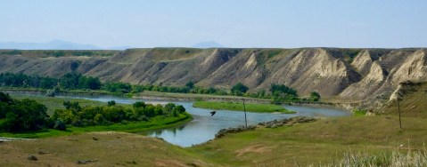
Standing on the same bluff–perhaps on the very spot–from which Lewis and Clark surveyed the Missouri and Marias rivers, I had this view of the Missouri River, which they proceeded up on June 12, 1805, on their way to the Pacific Ocean.
But the two captains overruled the common consensus, noting that the new river, the Marias River named for Lewis’s cousin, was muddier, indicating to them that it arose not in the mountains, but in the plains where it picked up dirt and mud as it made its way south. The river on the left, however, was clearer, indicating to them that it arose not in the dirt plains but in the rocky mountains. And so, at Decision Point, they correctly chose the Missouri River and proceeded on. Their decision was justified only a few days later when they discovered the Great Falls of the Missouri.
There are few places left on the Lewis and Clark Trail where today’s traveler can see what the Corps of Discovery saw. Decision Point is one of those locations, as was Pompey’s Pillar which I climbed yesterday. Standing in the same spot and seeing the same views is part of what this journey, for me, is about. It’s not the same experience, of course, but there’s something special about literally following in the footsteps of these intrepid explorers.
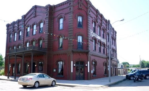
The Grand Union Hotel in Fort Benton was the finest lodging in the territory during that city’s prime years.
Up the river, about 10 miles as the crow flies or 15 miles as the river bends, one finds the historic town of Fort Benton, the commercial center of Montana in the 1830s to 1870s. With the appearance of hundreds of steamboats beginning in 1860 which brought supplies to the territory and returned its furry and golden treasure to the East, Fort Benton was the most inland port anywhere in the world. I stopped there today, in part to see the town where I would have started my canoe adventure had that been in the cards and to see the historic Grand Union Hotel I had planned to stay in. While most of Fort Benton’s history is unrelated to Lewis and Clark, their voyage of discovery in 1804-1806 opened the door to further exploration and exploitation of the area.
A small center, but full of interesting displays interpreted by a knowledgable staff.
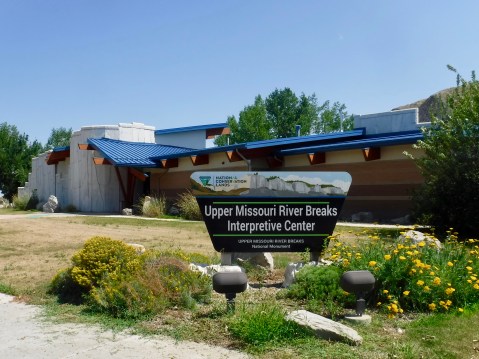
But I also wanted to visit the Upper Missouri River Breaks Interpretive Center operated by the Bureau of Land Management, which oversees the Upper Missouri River Breaks National Monument. Why was this important? Because the Upper Missouri River Breaks National Monument is the most pristine part of the Lewis and Clark Trail that remains, as the Missouri River flows past towering white sand stone cliffs and rock spires that inspire the imagination.
A few days before he reached Decision Point, Lewis had been mesmerized by the geologic wonders he saw as he made his way up river:
. . . . water in the course of time in decending from those hills and plains on either side of the river has trickled down the soft sand clifts and woarn it into a thousand grotesque figures, which with the help of a little immagination and an oblique view at a disance, are made to represent eligant ranges of lofty freestone buildings, having their parapets well stocked with statuary; collumns of various sculpture both grooved and plain, are also seen supporting long galleries in front of those buildings; in other places on a much nearer approach and with the help of less immagination we see the remains or ruins of eligant buildings; some collumns standing and almost entire with their pedestals and capitals; others retaining their pedestals but deprived by time or accident of their capitals, some lying prostrate an broken othes in the form of vast pyramids of connic structure bearing a sereis of other pyramids on their tops becoming less as they ascend and finally terminating in a sharp point. . . . . As we passed on it seemed as if those seens of visionary inchantment would never have and end; for here it is too that nature presents to the view of the traveler vast ranges of walls of tolerable workmanship, so perfect indeed are those walls that I should have thought that nature had attempted here to rival the human art of masonry had I not recollected that she had first began her work.
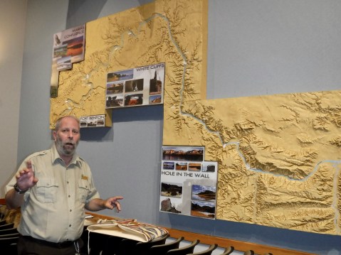
Bruce and a three dimensional map of the Monument helped me develop a mental picture of the sights and the Lewis and Clark history I missed by not going on the Missouri River Breaks canoe trip.
When I visited the Interpretive Center, I was assisted in my continuing Lewis and Clark education by a BLM staffer named Bruce and the Upper Missouri River Breaks National Monument Manager, Zane Fulbright. Bruce answered my questions about the Monument (which spans nearly 150 river miles and a narrow strip of land adjacent to the river) and about its appearance in 1805 compared with today. The short answer: There isn’t much difference. Toward the end of my visit, Zane spread out a Montana state map and together we went over the things I should see in the next couple of days. I don’t have time to see them all, but with Zane’s help I picked out the most important stops.
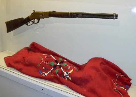
Chief Joseph’s rifle and a worn and faded blanket traded by a Nez Perce woman for food at the end of the siege at Bear Paw Battlefield.
Yesterday, I noted my visit to the Bear Paw National Battlefield. Today, in a sense, that visitation continued, when, to my surprise, I saw in the small collection of artifacts at the Center the very rifle that Chief Joseph held and surrendered to General Nelson Miles to end the New Perce War in 1877. It’s odd that the BLM has possession of the rifle. It seems odder that I stumbled on it today during my Lewis and Clark continuing education.
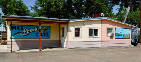
 At Decision Point, I had a decision of my own to make. At Ma’s Loma Cafe less than a mile from the point of land where the Corps camped, I had to decide which among half-a-dozen delicious looking slices of homemade pie I would have for lunch today. I chose the extraordinarily rich and heavy Sour Cream Raisin pie. Like Lewis and Clark, I made the right decision.
My glass is empty so this post must be done. But I’m sure there’ll be more tomorrow.

Fascinating information concerning Lewis and Clark. Pie looks great.
fascinating how they determined which river to take. Enjoyed seeing the rifle and blanket pic.
Glad your pie choice worked out too.
Choices…. interesting how the decided which river to follow. I would have used google earth 🌍
Interesting that BLM has a Chief Joseph’s rifle … there has to be a story there