
MHT Day 7: Across Missouri to Kansas
On June 26, 1804, 43 days after leaving Camp River Dubois, the Corps of Discovery reached the Kaw (Kansas) River where the Missouri turned north. That month and a half had been filled with hardships, dangers and significant tests to the mettle of all those involved in the expedition. That day, Clark recorded in his journal that the boats had “passed a bad Sand bar, where our tow rope broke twice, & with great exertions we rowed round it and Came to & Camped in the Point above the Kansas River.” But that day had not been unusual; everyday presented a trial of one sort or another. Still, the captains decided to spend three days at that point, repairing their boats as needed, taking a series of observations necessary to create accurate maps, and probably just resting a little before proceeding on.
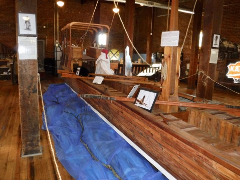
Half size model of the keelboat in Boonsboro. It seems as though every museum wants to get a piece of the keelboat action.
Today, I also reached that point at the confluence of the Kansas and Missouri rivers after riding nearly 200 miles on backroads from Columbia in the middle of the state. I had four destinations in mind today when I started out and I managed to spend time learning something new at each location. On June 8, 1804, the expedition had reached the area near Boonsboro and I took a look at how the folks there memorialized the visit. In a small but nicely done museum, the folks at Boonsboro displayed a half-size model of the keelboat that was useful in showing how the interior of the stern cabin had been arranged with sleeping quarters for the two captains.
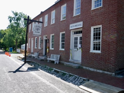
The historic tavern at Arrow Rock would have been a good place for a late breakfast, but the cleanup crews still have some work ahead of them to fix fire damage.
About 15 miles down the river the next day, the flotilla passed by Arrow Rock so I made that my next stop, anxious to see the rock. Except that there wasn’t really an Arrow Rock. At the Arrow Rock Interpretive Center I learned that the name was derived not from a singular, arrow-shaped rock but rather from the fact that the Osage Indians who lived in the area used rocks from a bluff near the river to make arrows. I also discovered that the river can’t be seen from the bluffs because of the heavy tree growth. So I strolled around the town of the same name, looking for the Huston Tavern, an eating establishment which had been billed as the oldest continuously operating restaurant west of the Mississippi. Once again my expectations were dashed because the tavern was temporarily closed thanks to a fire in May which had caused considerable damage to the kitchen. They had a tent set up where they served food, but somehow it wasn’t the same as an historic tavern.
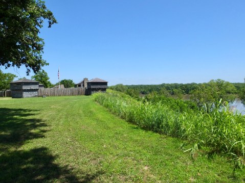
Fort Osage is an impressive site built under the auspices of a county government.
Westward I proceeded to Fort Osage, located high above the Missouri River. The fort was not there, of course, when Lewis, Clark, et. al., rowed by, but Clark, at least, must have thought the site special because after he returned from the expedition and was promoted to Superintendent of Indian Affairs in 1808 he ordered that a fort be built there not just for defensive purposes but to serve as a trading post to bring the Indians into a commercial relationship with the United States.

Site director Fred Goss walked me through the fort’s history.
The site, run by the Jackson County Parks Department is impressive, containing a reconstruction of the fort on the ground where the original had stood and a modern museum and educational center. I spoke with Fred Goss, the site administrator, for nearly 30 minute as we walked around the site and he pointed out significant features and answered my questions about Clark’s role in removing Indians from lands they had occupied for thousands of years. In the year the fort was built, the Osage signed a treaty that began the rapid diminution of tribal lands. Within 40 years they had signed away most of what they occupied for countless generations.
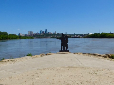
Cutouts of Lewis and Clark point the way north up the Missouri with the skyline of Kansas City, Missouri, in the background.
Finally, I was on to Kaw Point Park in Kansas City, Kansas, which is where they landed on June 26. Built in honor of the Lewis and Clark Bicentennial in 2004, this site is the location of frequent re-enactments of the three-day stay in 1804. Much of the site was covered with dried mud from the recent floods, but the perspective of the two rivers coming together was worth the stop.
My final stop for the day was in my old hometown of Topeka where I joined a dear friend from grade school, junior high and high school days for dinner and a talk that lasted well past mid-night. I had gone from exploring history of two centuries ago to reminiscing about a much more recent past. Now it’s very late ( 2 a.m.) and the quality of this blog probably shows it.
One more note: I rarely take Interstate or major highways when I’m traveling since everything flashes by without having time to properly appreciate it. On the Interstate I never would have had the opportunity to stop at a fresh fruit stand and eat the biggest, juiciest peach I’ve seen in a long time. That peach was my lunch today–what a treat.


The lady in the peach picture is keeping an eye on you.
Interesting day. Thanks for sharing! Ride safe.
So thankful that the weather in Kansas is taking a break. It feels like fall! Stay safe.
How do you manage to find so many representations of Lewis and Clark? I had no idea that there were so many.
It seems like being a history geek gets you quality time with directors of the places……. good job
Here is a question….. how did they decide which rivers to follow as they moved upstream ?? Water volumes/ flow rates……. inquiring minds want to know 🧐🧐🧐🧐🧐