
MHT Day 6: A Changing River
Today I traveled in about seven pleasant hours what the Corps of Discovery in 1804 managed in a little more than two labor-intensive, back-breaking weeks. From May 20 when they left St. Charles to June 4 when they passed the spot where Jefferson City, Missouri’s capital, now stands they covered about 125 miles up the river, or fewer than 10 miles per day. I actually rode nearly 200 miles, but there were some expected and unexpected detours involved.
The expedition group numbered about 48 men as it made its way up the Big Muddy, including 28 members of the permanent party who would go on to the Pacific, about 8 members who were scheduled to return to St. Louis before winter set in, and another dozen laborers, mostly French boatmen hired in St. Louis who knew the river and how to handle large boats in its dangerous currents.
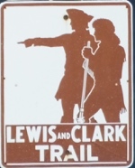 For most of the day, I followed roads that advertised the Lewis and Clark Trail with this sign. I’ll follow similar roads for the next 5,000 miles or so. (I’ve only logged 1,200 so far.) The National Park Service uses this sign to let motorists know they are about as near to the actual route of the expedition as they can be short of paddling or walking it. It will be a friendly reminder that I’m headed in the right direction as the miles roll by during the next three weeks or so.
One reason the Corps of Discovery took so much longer is that the Missouri River, as difficult as it is to navigate today in non-motorized craft, was a beast in 1804. It was much wider (more than 1/2 mile wide then, less than 1/4 of a mile now) and the surface area of the river water between here and St. Louis was three times greater. Oh, and the Army Corps of Engineers hadn’t begun to straighten the river and remove all the debris that spring floods uproot and deposit in terrible tangled masses to the great hazard of boatmen who couldn’t always see the snags.
Strong storms several hours before departure today made the roads a little slick, but they dried out before noon and at least I didn’t have to ride in the rain.
I, on the other hand, after a damp beginning, travelled some very nice asphalt roads in balmy temperatures, roller coasteering up and down the hills of rich farm country that stretched for miles on either side of the road. There was one section of Highway 100 not far from the river that was still closed either by debris on the road, or, more likely, water. I had expected the detour and anticipated which roads I would need to take on my alternate route. What I had NOT anticipated was that one of the roads called for in the detour was gravel, so, not knowing the condition or the length of the rocky road, I added a detour to my detour that padded today’s ride by about 25 or 30 miles. But it was beautiful countryside, and I sat back and enjoyed the scenery that whizzed by.
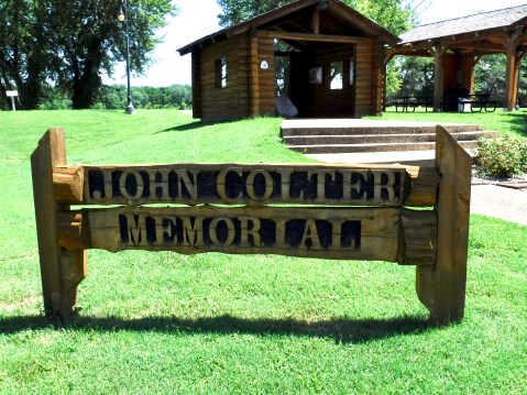
Stop One: The John Colter Memorial in New Haven on the banks of the Missouri.
I had planned three stops today at sites related to the expedition. First was a modest memorial to one of the crew’s better-known members: John Colter. Historians believe Colter had been picked up by Lewis in Pittsburg or shortly after leaving there as a “trial” member. Other than a couple of disciplinary matters which were resolved without much ado, Colter quickly became one of the expedition’s best hunters. He made it all the way to the Pacific and most of the way home, but when they got to within about 1,000 miles of St. Louis on the return, Colter asked to be released from service early; he wanted to return to the country they had just explored and seek his fortune trapping beaver. The seasoned mountain man made an infamous escape from the Blackfeet Indians after returning west and was probably the first European to see the extraordinary geysers, mud pots and canyons in what is now Yellowstone Park in Wyoming. Within a decade, he gave up trapping and the dangers of life in the west, bought a farm in Missouri near New Haven, and died and was buried there in 1812. In 2004, during the Lewis and Clark Bicentennial, local folks erected the memorial in his honor.
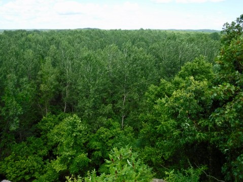
The view of the Missouri River from the top of Clark’s Hill.
The second stop was Clark’s Hill or Norton State Park about 20 miles east of Jefferson City. This was a rocky outcrop on a bluff above the confluence of the Osage and Missouri rivers where the party stayed for two days to take surveying and celestial measurements and was described by Clark in his journal entry for June 2, 1804: “. . . from this pt. which Comds both rivers I had a delightfull prospect of the Missouries up & down, also the Osage R. up.” I knew it was accessible and wanted to see what Clark had seen. So I rode half a mile down a potholed dirt road, hiked a mile up the hill and saw . . . Trees! Nothing but trees! I knew the Osage River had changed course about 100 years ago and now emptied about five miles further downstream. But I also knew–or thought I did–that the Missouri River was still there. Near the top of the trail I met, Linda, a volunteer working for the Missouri Natural Resources Department trying to remove invasive species along the trail, who explained to me that the Army Corps of Engineers had in the last 30 years or so deepened the river channel on the northern side, which in turn made the river narrower and the bottoms wider, which in turn provided a prime spot for cottonwood trees to thrive, which in turn blocked MY view of Clark’s view. Oh well, it was pleasant hike, and I had nice conversation with Linda while I caught my breath for the downhill return.
Finally, I wanted to stop at the State Capitol and Museum in Jefferson City, because I had read that it contained a few items and memorials related to Lewis and Clark. Once again, I was a little disappointed in what I discovered. First, the Capitol is undergoing major renovations to prepare for the state’s upcoming bicentennial and it’s wrapped up like some weird Christmas present while workers clean the exterior surfaces. And there’s green chain-link construction fencing all around which prevents weary motorcycle riders from getting too close.
 One item in particular I hoped to see was a statue of one of my favorite presidents, but they had the city’s namesake in a cage. I’m not sure if they’re making a political statement given the current administration’s predilection for putting people in cages or whether it’s just part of the construction process.
In the museum inside the Capitol, I learned that the limited exhibit space was given over to a centennial look at Missouri’s role in WWI and to the upcoming bicentennial. They did have two large statues of Lewis and Clark in the rotunda but they were set back in dark alcoves and didn’t do much for me. On the outside, on the Capitol grounds, I finally found a fairly decent memorial erected during the Lewis and Clark bicentennial in 2004-2006. Although I think the artist took liberties with the appearances of the figures in her tableau, it was nice to see Clark’s slave York (they referred to him as Clark’s “man-servant”) and French-Indian George Drouillard included in the group.
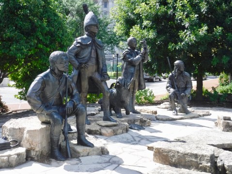
York, Lewis, Seaman, Clark the mapmaker, and Drouillard, York and Drouillard are just guesses, of course, since there are no portraits of them available.
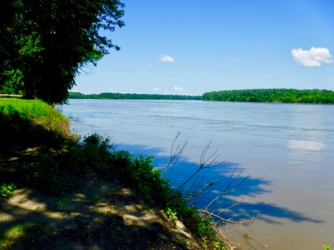
I had several good looks at the Big Muddy as I crossed it and stopped next to it several times today. Today’s river is mighty, but it’s a far cry from the wild river that the Corps of Discovery ascended in 1804.

I am really enjoying the trip with you by reading your blog. It’s wondered that you did not let your little hiccup at the start deter you from what you obviously enjoy so much. The pictures are great too! …. as always! Please ride safely, and thanks for your blog. ~C. Shane Marcus
Glad not much rain to deal with but it seems timing is everything with the preparations you have encountered. Ride safe!
Amazing all the museums and monuments along the way. So on that guide sign with Lewis and Clark profiles…. who is who. Who is pointing?