
MHT Day 22: Half Way There
Great joy in camp we are in View of the Ocian,. . . . this great Pacific Octean which we been So long anxious to See Captain William Clark, November 7, 1805
Oh Crap. Now I have to turn around and go back. Dr. Dennis Frobish, August 7, 2019
Captain’s Clark’s comment when he reached the Pacific Ocean on a cold, rainy November day in 1805 is often quoted; my comment, after achieving the same goal, will no doubt rightly be consigned to the dust bin of history. Nevertheless, more than two and a half years after starting his trek with Captain Meriwether Lewis on the banks of the Ohio River, Clark and the Corps of Discovery fulfilled another of President Thomas Jefferson’s instructions to Lewis and the expedition:
The object of your mission is to explore the Missouri river, & such principal stream of it, as, by it’s course & communication with the water of the Pacific ocean may offer the most direct & practicable water communication across this continent
I’m not bragging, but I made the outward bound trip in three weeks. Of course, I had GPS. And I was standing on the shoulders of giants. Metaphorically, of course, because I was actually riding a Harley-Davidson.
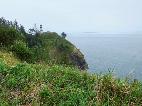
Cape Disappointment and the Cape Disappointment light house, where the Columbia River meets the Pacific Ocean. The river flows in from the left.
Technically, Clark was seeing the expansive bay at the mouth of the Columbia River and not the ocean when he made that comment and the weather and high wind and massive waves meant it would take another 10 days before he actually reached Cape Disappointment, and he had to cover the final 12 miles on foot. Still one has to admit, he and the members of the party had just completed, with the help of countless Native Americans, an amazing, incredible, awe-inspiring, stupendous, historic trip.
During the final three weeks of their westward voyage, the Corps encountered more falls, more rapids and a variety of animals they had never seen before, including seals that swam all the way to Celilo Falls. And they also encountered more than a dozen new, but relatively small, tribes of west-coast Indians whose culture, language and various skills related to life in a wet, coastal climate posed new challenges and new opportunities. These Indians had experience with white Europeans for more than a decade, beginning with American sea captain Robert Gray’s first visit to the waters of the Columbia River in 1792 followed by English ships shortly thereafter. Trade with other tribes had been part of Columbia Indian culture for thousands of years, and trade with the white newcomers continued that tradition. That trading practice was fortunate for the Corps, of course, because it allowed them to trade trinkets and small goods for the food that kept them alive until they found game on the south side of the river where they wintered.
But they also encountered dramatic geologic formations and geographic climate changes and they passed through a landscape sculpted over hundreds of millions of years. For example, as they moved from the semi-deserts of western Washington and Oregon to the Cascades and coastal areas, the areas went from an annual rainfall of 10 inches to an average rainfall of more than 100 inches, most of the latter falling during the months spent on the Pacific coast. Yesterday I ended my day on the semi-desert side with temperatures of more than 100°; today, 170 miles further west, I finished the ride at 69° with my leather jacket on.
On October 31, Clark recorded in his journal that
a remarkable high detached rock Stands in a bottom on the Stard Side near the lower point of this Island on the Stard. Side about 800 feet high and 400 paces around, we call the Beaten [NB: Beacon] rock.

850 foot tall Beacon Rock dwarfs my ride.
Beacon Rock is still there today, and Clark’s estimate of its height was off by only 20 feet. Clark did not, and probably could not, have climbed that massive rock. But today, thanks to an early 20th century entrepreneur, a steep and rocky path with a series of bridges and boardwalks and scores of switchbacks allow visitors to Beacon Rock State Park in Washington to climb to the top. The path is almost a mile long and is the equivalent of climbing a 75-story building. But it’s not a building; it’s a volcanic core that hardened 57,000 years ago whose outer layers were eroded away by ice-age floods 600 feet deep and moving at 60 mile-per-hour, sweeping by the small volcano and eroding its outer layers leaving only the rock visible to Clark and to us today.
Since I gave my shoulders a work-out last night kayaking on the Columbia River, I thought I’d balance my on-the-road work-out routine with a a quick scamper to the top. Well, with a slow climb to the top, anyway. It took nearly 30 minutes to make the one-mile climb, but the view of the Columbia River Gorge more than matched the effort.
So. I’ve ridden the outward bound journey of the Lewis and Clark expedition. In the process, I’ve learned new things and confirmed other things I thought I knew. The Lewis and Clark crew, as I came to realize while reading the 5,000 pages of their journals last winter, were hard-working, disciplined, tenacious, determined, resourceful, and damned lucky not to have died on this expedition into the unknown. While I knew, to some extent, the degree to which the natives they encountered aided them in reaching the Pacific Ocean, I now believe that without that aid, the expedition would have been a failure. For historians who have studied the expedition, this is common knowledge. For me, it was a revelation and has given me much to consider.
I wish I could have seen the country they saw as they saw it. But what I saw of Missouri, Kansas, Nebraska, Iowa, South Dakota, North Dakota, Montana, Idaho, Washington and Oregon reminded me, as all my cross-country motorcycle trips remind me, that we live in a gorgeous country full of amazing people.
In the winter of 1805-1806, the Corps spent a miserable four months on the south side of the Columbia River near the Pacific coast. More on that tomorrow after I’ve visited Fort Clatsop where they huddled, wet and cold, until they could begin the trip back to St. Louis. After tomorrow, I too will turn around and head east, retracing some of the same route but also following, when I can, deviations they made to accelerate their return to their pre-expedition lives.

Enjoy the left Coast and hopefully you will miss most of those 100 in of rain fall! Ride safe.
Just wanted you to know that we are enjoying riding along with you exploring this great nation. Looking forward to more enlightenment on your return trip. Thanks for taking the time to write about each days adventure and in doing so let us come along with you.
Thanks for sharing your outbound journey. Chuckled at the quote “Oh Crap” beautiful pics.